This New Orleans walking route connects Tremé, the Marigny, and Bywater through places that deserve more than a photograph taken while moving.
| Quick Facts | Details |
|---|---|
| Route distance | Approximately 3.3 miles, including the stops below; checked in Google Maps in October 2026 |
| Estimated walk time | Google Maps displayed 1 hour 14 minutes without stops; allow 3–4 hours for food, photographs, and reading |
| Difficulty | Moderate as a sightseeing outing; mostly flat, but distance, heat, uneven sidewalks, and the final bridge matter |
| Terrain | City sidewalks, park paths, street crossings, and the stepped Rusty Rainbow bridge |
| Best time to walk | A daylight morning; 8:30 a.m. is a suggested start, not a guarantee of cooler conditions |
| Dog-friendly | Partial: outdoor route only; confirm individual venue rules and bring water |
| Stroller/wheelchair accessible | Not reliably accessible as written. The final bridge involves stairs; current elevator operation elsewhere in Crescent Park wasn’t confirmed |
| Public transit access | The French Market identifies Riverfront streetcar service and buses serving the district; confirm your departure in the RTA planner |
| Parking near start | Premium Parking’s P401 lot, 500 Decatur Street; obtain a date-specific quote before arriving |
| Restrooms on route | Limited and not operationally verified. Ask at food stops; don’t depend on Crescent Park facilities |
| Food and coffee stops | Three: Café Du Monde, Ayu Bakehouse, and Elizabeth’s |
| What makes it worth it | A walk connecting Black cultural history, neighborhood streets, and the working river without making Bourbon Street the main event |
| Verification limits | Researched October 26, 2026, not field-tested. Several operational pages lack update dates; hours, facilities, and unrestricted passage need reconfirmation |
Walk New Orleans: Skip Bourbon, Find the River
At Café Du Monde on Decatur Street, powdered sugar gives you an immediate logistical problem: where to put your hands before touching your phone. Order coffee, brush yourself off, and resist the assumption that the rest of the morning belongs to the French Quarter. Your first destination sits inland, across North Rampart Street, at Congo Square. The river can wait; the order matters.
This New Orleans walking route connects Tremé, the Marigny, and Bywater through places that deserve more than a photograph taken while moving. It’s for walkers who want historical context, a proper food stop, and enough ordinary residential streets to understand the spaces between attractions. Prospective residents should find those in-between blocks especially useful: a bakery visit and a sidewalk tell you different things than a property listing.
One correction keeps this walk honest: Magazine Street belongs to a separate outing, not an imaginary shortcut through these neighborhoods. The mapped itinerary here measures approximately 3.3 miles, rather than the proposed four or five. Start with coffee, then head toward Congo Square. Sources: Café Du Monde, community discussion of separate neighborhood outings
Route Snapshot — Tremé to the River, New Orleans
| Stop | Landmark or point of interest | Approximate distance from start | Notes |
|---|---|---|---|
| Start | Café Du Monde, 800 Decatur Street | 0.0 mi | Coffee is optional; this is the meeting point |
| 1 | Congo Square, Louis Armstrong Park, 701 North Rampart Street | 0.7 mi | Read the place before photographing it |
| 2 | St. Augustine Church, 1210 Governor Nicholls Street | 1.3 mi | Exterior stop; don’t assume interior access |
| 3 | Ayu Bakehouse, 801 Frenchmen Street | 1.9 mi | Breakfast or a pastry break |
| 4 | Plessy v. Ferguson historical marker, Royal and Press streets | 2.5 mi | Stop clear of the railway |
| 5 | Elizabeth’s, 601 Gallier Street | 3.0 mi | Meal stop; confirm service before setting out |
| End | Crescent Park, 3230 Chartres Street map destination | 3.3 mi | Piety Street bridge area; stairs affect access |
Intermediate mileages are rounded planning figures from individual walking legs, not surveyed markers. The complete Google Maps itinerary displayed 3.3 miles.
Check This Out!
Mystic Town Guide: The Complete Explorer’s Manual
Map the Tremé-to-River Detour
The route first turns inland from Decatur Street toward Congo Square, then continues into Tremé. It bends back toward the Marigny through Governor Nicholls and Dauphine streets before reaching Frenchmen Street. Royal Street carries the next stretch toward Press Street and Bywater, with Crescent Park providing the riverward finish. This is a point-to-point walk, not a loop.
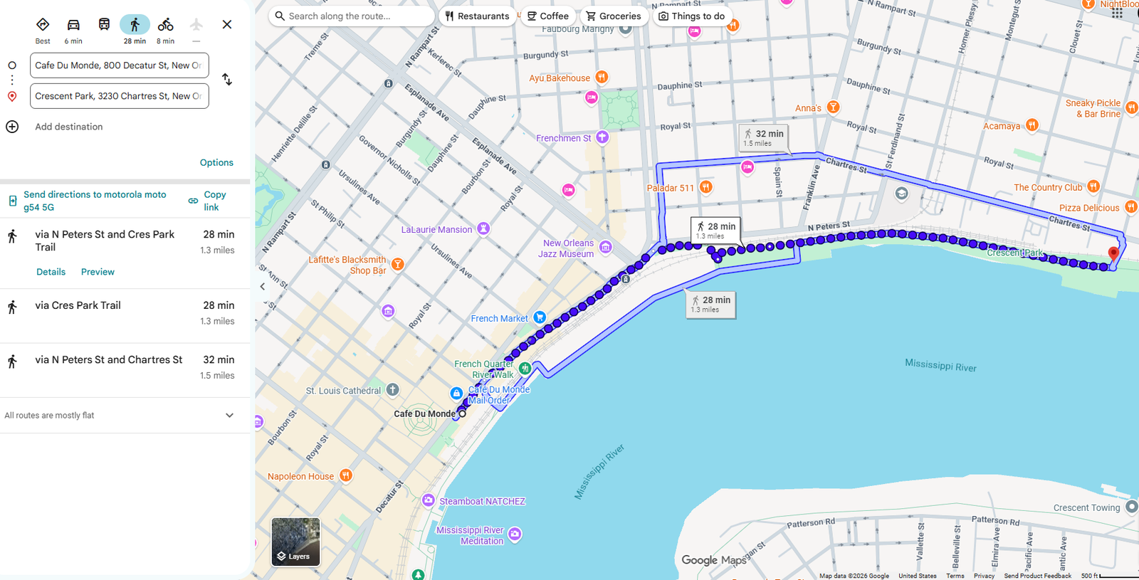
Open this route in Google Maps and select Walking. That verified endpoint link initially offers a direct walk of approximately 1.3 miles and 28 minutes, which skips this article’s inland stops. Add Congo Square, St. Augustine Church, Ayu Bakehouse, the Plessy marker, and Elizabeth’s in the table’s order; the complete itinerary displayed 3.3 miles and 1 hour 14 minutes. Google also flagged restricted usage or private roads, so treat park gates and posted access rules as controlling.
Begin With Congo Square
Leave Café Du Monde and use St. Ann Street toward North Rampart Street and Louis Armstrong Park. This crossing of the Quarter may take you across Bourbon Street; the promise is to skip its entertainment corridor, not pretend the street disappears. Cross North Rampart carefully and follow the available public entrance toward Congo Square. Don’t let the park’s larger setting swallow the reason you came.
The New Orleans Jazz & Heritage Foundation identifies Congo Square as a gathering place where enslaved African people practiced ancestral traditions on Sunday afternoons. That history deserves more attention than the familiar shorthand that simply labels somewhere a birthplace of music. Pause here before moving into Tremé, and consider what public gathering meant under slavery. The Foundation’s 2026 festival account supplies context without requiring you to imagine a performance happening today.
There’s also a practical reason to begin here rather than finish here. This stop asks for concentration, while the river makes a better place to let the morning loosen up. Read what you can find on site, but don’t expect a scheduled drum circle or second line. Living traditions aren’t an attraction you can summon by arriving with a camera.
Give St. Augustine Some Time
Continue to St. Augustine Church at 1210 Governor Nicholls Street, using the North Rampart route if park gates prevent a direct exit. The separately checked walking option via North Rampart measured approximately 0.6 mile from Congo Square. Keep this an exterior stop unless the church explicitly welcomes visitors inside. A functioning place of worship doesn’t owe the itinerary an open door.
The parish identifies a garden memorial called the Tomb of the Unknown Slave, honoring enslaved people whose graves and names remain unknown. Its own explanatory page is undated, so this guide doesn’t treat that page as a freshly updated access notice. Look for posted information and approach only where public access permits. The parish’s description of the memorial explains why the stop warrants more than a quick architectural glance.
From the church, the checked route toward Ayu uses Governor Nicholls and Dauphine streets. Follow that connection toward Frenchmen rather than drifting back toward the river too early. This middle stretch is part of the outing, not dead space between famous names. Keep entrances clear, photograph from public sidewalks, and let residents get on with their day.
Meet Frenchmen Before Nightfall
Ayu Bakehouse at 801 Frenchmen Street gives this route a useful daytime anchor. You don’t need to return after dark to justify coming here, and breakfast makes a perfectly respectable cultural plan. The bakery describes its open kitchen as a way to reveal production that usually happens out of sight. Watch the work rather than treating the counter as a pastry vending machine.
That visible preparation is one of the walk’s quieter rewards. A building can tell you something through its use, not just its age or ornament. At Ayu’s open kitchen, the useful detail is the relationship between the public room and the baking operation. You’re seeing a neighborhood business work, which beats making unsupported claims about what “all the locals” supposedly do.
After the break, connect to Royal Street and continue toward Press Street. The checked walking leg from Ayu to the Plessy marker measured approximately 0.6 mile. Give yourself permission to move slowly, but keep the sidewalk usable for everyone else. A leisurely walk shouldn’t become a stationary group project.
Read Royal and Press
At Royal and Press streets, stop at the Plessy v. Ferguson historical marker before continuing into Bywater. The railway setting makes the historical connection more immediate than a detached museum label would. Read from a safe public position and stay clear of tracks and railway operations. A better photograph isn’t a reason to negotiate with a train.
The National Park Service explains that Homer Plessy volunteered for an organized challenge to Louisiana’s Separate Car Act. His planned arrest on June 7, 1892, led to the case that reached the Supreme Court. In 1896, the Court upheld the law and the doctrine commonly called “separate but equal.” The NPS account of Plessy’s action makes an essential distinction: this was coordinated civil-rights resistance, not an accidental disagreement over seating.
Continue along Royal Street toward Gallier Street, then reach Elizabeth’s at 601 Gallier. This checked leg measures approximately half a mile. Don’t make the marker compete with lunch by reading it while hungry and halfway across an intersection. Stop first; the restaurant will still require its own decision.
Eat Along Frenchmen and Gallier
Café Du Monde, 800 Decatur Street: Order café au lait and beignets if you want the classic start rather than another full breakfast. Its live website lists 7:15 a.m.–11 p.m. Sunday–Thursday and 7:15 a.m.–midnight Friday–Saturday, but provides no visible update date. Treat those as published hours requiring reconfirmation, not a date-certified operating guarantee; a current meal price wasn’t verified. Source: Café Du Monde
Ayu Bakehouse, 801 Frenchmen Street: Choose the Boudin Boy for something substantial or the mushroom-filled Shroom Boom for a savory vegetarian pastry. Published hours list 8 a.m.–2 p.m. Monday–Tuesday and 8 a.m.–3:30 p.m. Wednesday–Sunday, but the page lacks an update date. Its homepage and full menu disagree on some prices, so check the counter rather than budgeting from a stale number. Sources: Ayu, full menu
Elizabeth’s, 601 Gallier Street: Consider this the sit-down meal stop rather than another compulsory snack. The restaurant publishes breakfast and brunch menus, but its retrieved pages and listings don’t establish a consistent, recently dated weekly schedule. Confirm service directly before building lunch around it; weekend brunch is first come, first served according to its menu page. Source: Elizabeth’s service information
You don’t need to eat at all three places to complete the walk properly. Café Du Monde can be coffee only, Ayu can be the main breakfast, and Elizabeth’s can remain optional. That flexibility matters more than collecting three receipts. Food should support the route, not turn it into a series of deadlines.
Finish at Crescent Park
From Elizabeth’s, the checked final leg reaches the Crescent Park destination at 3230 Chartres Street via the Rusty Rainbow bridge. Allow extra time beyond the short mapping estimate for finding the entrance and assessing the stairs. The bridge is a real access consideration, not a decorative flourish in the directions. If steps don’t work for you, finish on the neighborhood side.
The Bywater Neighborhood Association identifies the Piety Street crossing as David Adjaye’s Rusty Rainbow. Its account describes Crescent Park as reclaimed wharf and industrial space, which gives the finish a different character from a conventional garden park. Look at the relationship between the bridge, railway barrier, and riverfront rather than hunting only for a skyline photograph. That separation helps explain both the park’s appeal and its access limitations. Source: Bywater Neighborhood Association
An additional riverfront stroll is optional and isn’t included in the mapped 3.3-mile itinerary. Enter only if gates are open and the remaining daylight, weather, and your energy make sense. Check the exit before committing to a longer walk inside. The Mississippi makes a fine finish without demanding an endurance sequel.
Notice What Connects These Stops
The most rewarding details here aren’t all tiny or secret. Congo Square’s gathering history, St. Augustine’s memorial, Ayu’s visible production, and the railway setting at Press Street each change how you read the surroundings. They connect culture to specific public spaces and working buildings. None requires an invented legend about an unnamed doorway.
The Plessy stop especially rewards a second look after you understand the organized legal challenge. The NPS account identifies a committee, a willing participant, and a planned arrest. Remember that coordination when you return your attention to the ordinary intersection. History didn’t require a grand staircase to happen here. Source: National Park Service
For someone considering a move, the useful exercise is equally specific. Notice whether the Governor Nicholls–Dauphine connection feels comfortable at your pace, and whether Frenchmen supplies the kind of daytime stop you’d actually use. Consider the practical consequences of uneven walking surfaces and limited riverfront exits. Don’t confuse enjoying one morning with completing neighborhood due diligence.
Plan Around Park Access
Choose shoes with grip and enough support for inconsistent sidewalks, not footwear selected entirely for the brunch photograph. Carry drinking water before leaving the start; this research didn’t verify functioning public fountains along the itinerary. Use food stops to ask about restrooms rather than assuming park facilities will be available. None of those businesses guarantees bathroom access without a purchase or permission.
For transit, the French Market identifies Riverfront streetcar service and buses serving the district. RTA’s live fare page lists $1.25 for an adult single ride and $3 for a one-day Jazzy Pass, but doesn’t provide a visible update date. Confirm the fare and exact stop in the official planner before departure. A return ride from Bywater should be planned, not discovered when your feet resign. Sources: French Market, RTA fares
Drivers can investigate P401 at 500 Decatur Street, but a reliable date-specific parking price wasn’t retrievable. Obtain a quote for the full outing, including your return to the car. Also check the forecast rather than treating an autumn date as a cooling system. The city’s heat guidance recommends regular water, reduced exertion during peak heat, and air-conditioned breaks.
The Riverfront Has Conditions
The honest drawback is uncertainty at the finish. June 2025 reporting documented late openings, early closing procedures, and complaints about maintenance during a management transition. Those reports establish past problems, not the condition of every gate today. Current research didn’t confirm a fully unobstructed route or operational park restrooms and elevators. Source: The Times-Picayune
Community accounts don’t provide one tidy verdict either. In a discussion about Crescent Park’s closing time, commenters disagreed about hours and raised concerns about bathrooms and elevators. Elsewhere, walkers praised everyday walkability while describing raised sidewalks and groups blocking passage. These are useful experiences to consider, not verified current facility reports or neighborhood crime statistics. Sources: park-hours discussion, walking discussion
Walk this as a daylight outing and assess conditions as you go. This research doesn’t support declaring every block safe for every solo walker, family, or mobility level. If an entrance is closed or a stretch feels uncomfortable, shorten the plan or arrange a ride. Finishing an itinerary isn’t a civic obligation.
Who Tremé to Bywater Suits
This walk suits someone who wants a historical stop to interrupt breakfast, not merely decorate it. You’ll enjoy it if reading a marker, watching bakery work, and taking the longer neighborhood connection count as a good morning. Choose another plan if you need guaranteed step-free passage, frequent verified restrooms, or continuous entertainment. The point isn’t that these neighborhoods are more “real” than the Quarter; it’s that they deserve attention on their own terms.
Your Tremé-to-River Checklist
- [ ] Save the seven stops in order; the endpoint-only map skips the inland route.
- [ ] Wear grippy walking shoes for inconsistent sidewalks and bridge steps.
- [ ] Confirm Louis Armstrong Park’s gate access before an early start.
- [ ] Check Ayu’s shorter Monday and Tuesday hours.
- [ ] Confirm Elizabeth’s service day directly before planning lunch there.
- [ ] Carry water; functioning public fountains weren’t verified.
- [ ] Ask about restrooms at a food stop before heading toward the park.
- [ ] Check Crescent Park’s posted closing time on arrival.
- [ ] Don’t depend on an elevator without same-day confirmation.
- [ ] Arrange the return journey before entering the riverfront.
- [ ] Keep railway tracks, residential entrances, and narrow sidewalks clear.
New Orleans Walking Questions
Can you walk beyond the Quarter?
Yes—this approximately 3.3-mile itinerary connects the Quarter with Tremé, the Marigny, and Bywater. Community recommendations specifically identify Marigny, Bywater, and Crescent Park as worthwhile outings beyond the Quarter. The full itinerary requires the intermediate stops, not just the start and finish entered into Maps. Source: r/AskNOLA
Does Magazine fit this walk?
No—Magazine Street and the Garden District should be a separate outing. The community discussion distinguishes those areas from the Marigny–Bywater direction. Adding them would change this itinerary substantially rather than supply a minor detour. Source: neighborhood outing recommendations
Are the sidewalks consistently easy?
No—walkers report raised sidewalk sections and occasional obstructions. A recent walking discussion pairs enthusiasm for the city’s walkability with complaints about tree-root damage and groups blocking passage. Mostly flat terrain doesn’t mean a uniformly smooth route. Source: r/NewOrleans walking discussion
Can you depend on park bathrooms?
No—current operational restroom access in Crescent Park wasn’t verified. Community comments describe locked or unavailable facilities, but those accounts don’t establish today’s status. Plan a restroom request at a food stop before the final stretch. Source: Crescent Park facilities discussion
Can you finish after work?
Possibly, but don’t plan an evening finish without confirming Crescent Park’s closing time. Residents have disputed early closures and changing schedules. This guide recommends a daylight morning partly to avoid making the park’s last admission your problem. Sources: community discussion, local reporting
Is this a step-free route?
No—the route as written finishes via a stepped bridge and doesn’t provide verified step-free access. Elevator availability elsewhere in Crescent Park remains unconfirmed. Walkers who require step-free passage should revise the endpoint before departure rather than improvise at the bridge. Sources: park crossings, access concerns
Let the River Finish It
Skipping Bourbon Street isn’t a moral achievement, and the Quarter doesn’t become less authentic because visitors enjoy it. The better reason to walk farther is that distance changes your attention. You begin connecting public memory, everyday work, residential streets, and the physical barriers around the river instead of consuming each place as a separate attraction.
That’s what this route offers when conditions cooperate: not exclusive access to a secret city, but a more patient way of reading a public one. Leave room for a closed gate, a longer breakfast, or a decision to stop before the bridge. A good urban walk gives you choices rather than homework. This one is waiting for the person who’d rather understand three miles than collect ten.
One thought on “New Orleans on Foot: Tremé, Marigny, and the River”