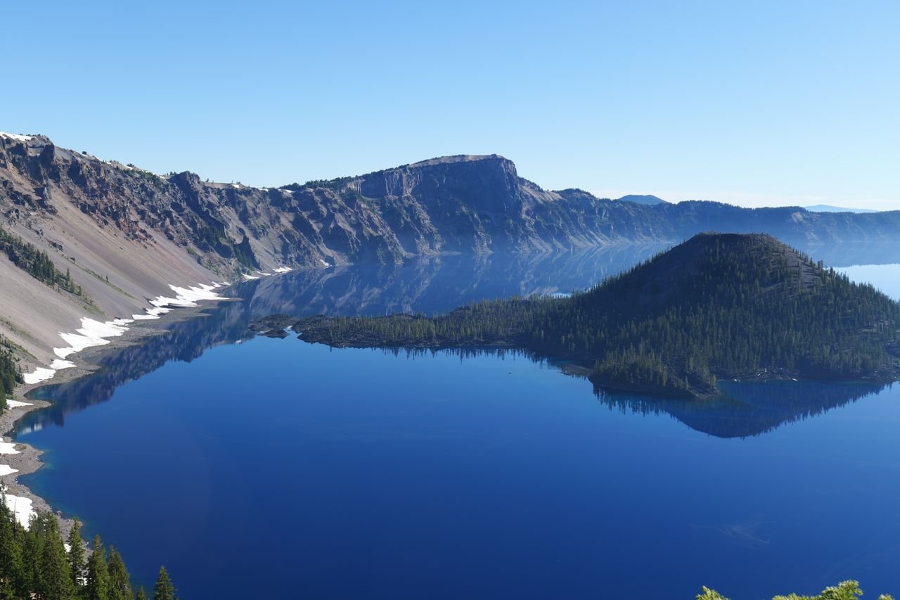
Crater Lake’s gate runs $30 per vehicle. Here are 15 verified free things to do in Crater Lake, Oregon, plus no-cost stops in three nearby towns.
Crater Lake National Park charges $30 per vehicle this season. Nobody prices out what happens after that gate: the rim, the overlooks and the trails all cost nothing more. These 15 free things to do in Crater Lake reach three nearby towns too.
Quick answer: the 3 best free things to do in Crater Lake, Oregon
- Rim Drive — 33-mile loop around the caldera with 30 overlooks; free once you’ve paid the park entrance fee.
- Rim Village Walking Tour and Sinnott Memorial Overlook — a third-of-a-mile promenade at the south rim; free with park entry, overlook exhibits usually open through mid-October.
- Collier Memorial State Park and the Collier Logging Museum — off Highway 97 in Chiloquin, between Klamath Falls and the park; free admission, no day-use parking fee.
Last checked 11 October 2026: costs, hours and conditions below were confirmed against current official pages.
15 Free Things to Do in Crater Lake, OR
Around Rim Village and park headquarters
Rim Drive
Cost: Free once the park entrance fee is paid ($30 per private vehicle May 22–Oct 31, $20 Nov 1–May 21) · Where: loops the caldera; enter from Rim Village or the Steel Information Center · Hours: open now; closes November 1 or earlier with snow · Heads-up: narrow, winding, no shoulders, 35 mph, shared with bicyclists
Thirty-three miles, 30 overlooks, and each one was positioned between 1931 and 1938 to frame something specific. Visitors average about two hours for the loop with eight or more stops, so plan a slow half day, not a photo sprint.
One practical note: the park has no street address, so set “Rim Village” as your waypoint before you lose signal. NPS lists Rim Drive details here.
Rim Village Walking Tour
Cost: Free with park entry · Where: Rim Village, south rim · Hours: promenade open daily; Rim Visitor Center 9:30 a.m.–5 p.m. · Heads-up: dog-friendly, paved, restrooms at Rim Village open 24 hours
Start at Kiser Studio, the 1921 photographer’s building that now houses the Rim Visitor Center and the park bookstore, then follow the native stone parapet for a third of a mile along the caldera edge. Three observation bays break up the walk.
The route passes Mather Observation Bay, named for the first National Park Service director. Read the panels between the café and Crater Lake Lodge; that’s where the design story lives. The park’s walking tour page maps every stop.
Sinnott Memorial Overlook
Cost: Free with park entry · Where: Rim Village, built 50 feet below the rim into Victor Rock · Hours: typically late June to mid-October; hours vary · Heads-up: deep snow keeps it closed the rest of the year
The park calls this its most popular overlook, and the 1931 stonework explains why. Inside are exhibits on Mount Mazama’s collapse and on the Indigenous connections to Crater Lake.
Step outside and the view runs toward Wizard Island, Llao Rock and Mount Thielsen from 7,100 feet. Mid-October is usually the last week, so treat it as a bonus, not a guarantee. The park’s overlook page carries the seasonal hours.
Steel Information Center
Cost: Free with park entry · Where: Park Headquarters, 6,450 feet, three miles south of Rim Village · Hours: 9:00 a.m.–5:00 p.m. daily, closed December 25 · Heads-up: cashless park; restrooms, drinking water, wheelchair accessible
Twenty-two minutes, free, every half hour. The film covers how the lake formed and what the eruption did to everything around it, which makes every overlook afterward read differently.
The building just came back from a structural renovation that stabilized it against seismic and snow load. Buy stamps here and mail a postcard; it’s the cheapest souvenir that actually gets used. Current hours are posted here.
Castle Crest Wildflower Trail
Cost: Free with park entry · Where: East Rim Drive, 0.25 mile east of park headquarters · Hours: open with the road, through November 1 or first heavy snow · Heads-up: 0.5-mile loop, 100 feet of gain, rocky and slippery in places
At 6,300 feet and 2,000 feet below Castle Crest Ridge, this loop circles a spring-fed meadow holding more than 200 documented wildflower species. It was laid out in 1929 and improved by the CCC in 1938.
Honest October note: peak bloom runs mid-July to mid-August, so right now you’re here for the quiet meadow, the moss and the late asters. Self-guiding brochures sit at the trailhead. NPS describes the trail here.
Lady of the Woods Trail
Cost: Free with park entry · Where: behind the Steel Visitor Center at park headquarters · Hours: daily · Heads-up: 0.7-mile loop, 120 feet of gain, pets allowed on leash
Half an hour, brochure in hand, and you get a stone sculpture, historic headquarters structures and a forest loop that never asks much of your knees. It’s the easiest pet-friendly walk in the park.
That matters, because Crater Lake allows dogs on only a few trails. If fencing blocks the signed trailhead, follow the fence left toward the Ranger Station; the park’s own trail list notes the workaround.
Plaikni Falls Trail
Cost: Free with park entry · Where: Pinnacles Road, 1.2 miles off East Rim Drive near Phantom Ship Overlook · Hours: daylight; road closes with East Rim Drive on November 1 · Heads-up: 2.0 miles round trip, 100 feet of gain, first three-quarters accessible to all-terrain wheelchairs
A snowmelt-fed waterfall at the end of a gentle old-growth walk, with wildflowers through midsummer. Bend right and listen: the park says to expect pika, marmot and songbird traffic in that stretch.
Two 2026 realities. Trailhead parking is limited, and Pinnacles Road is closed to vehicles, so you walk or bike in from East Rim Drive. Pack water; Lost Creek Campground, the nearest restroom stop, is closed this season.
Annie Creek Trail
Cost: Free with park entry · Where: Mazama Village; park at the Mazama Store lot and walk through the campground to the amphitheater between loops D and E · Hours: daily · Heads-up: 1.7-mile loop, 200 feet of gain, no pets
The loop drops steeply through switchbacks, then flattens for a streamside stroll in a canyon cut by the creek. American Dippers work the water here, and the meadows carry pollinators into early fall.
It sits beside the Mazama Amphitheater, so stack it with a picnic. Leave the dog behind: pets are not allowed on this trail.
Cloudcap Overlook
Cost: Free with park entry · Where: East Rim Drive near the Mount Scott Trailhead · Hours: open when East Rim Drive is open; both close November 1 or earlier · Heads-up: highest paved overlook in the park
Highest paved overlook in the park, and it draws a fraction of the Rim Village traffic. The trade is the drive: you climb East Rim Drive past the Mount Scott Trailhead, and the road narrows.
Check conditions the morning you go. The park averages 21 inches of snow in October, and one storm can shut East Rim Drive weeks before November 1. My take: this stop earns more than any gift-shop detour on your list.
Watchman Peak Trail
Cost: Free with park entry · Where: West Rim Drive, 3.8 miles northwest of Rim Village; park at Watchman Overlook · Hours: daily while West Rim Drive is open · Heads-up: 1.6 miles round trip, 420 feet of gain, extremely crowded at sunset
The park’s own trail description opens with a warning: this one gets extremely crowded, especially at sunset. The climb is a moderate ascent to a historic fire lookout with 360-degree views.
Go late afternoon, an hour before the light turns, and the lot at Watchman Overlook is usually workable. Arrive at sunset and you’ll spend golden hour hunting a place to stand. Trail details are here.
Best time of day: Watchman Peak, 45 to 60 minutes before sunset. The lookout gives 360 degrees, so you catch the light on Wizard Island and the Cascade skyline at once.
NPS flags the trail as extremely crowded at sunset, so that early window is also your only realistic shot at parking at Watchman Overlook.
Sun Notch Trail
Cost: Free with park entry · Where: East Rim Drive, 4.4 miles from park headquarters · Hours: daily while East Rim Drive is open · Heads-up: 0.8-mile loop, 150 feet of gain, uphill both ways through a meadow
Thirty minutes up a grassy slope and the Phantom Ship appears, a rock island that reads exactly like a tall-masted vessel from the rim. Short, family-tolerant, immediate payoff.
Late afternoon light hits the formation from the west, which is when the silhouette does its best work. It pairs cleanly with Castle Crest on the same stretch of East Rim Drive.
Collier Memorial State Park and the Collier Logging Museum
Cost: Free; Oregon State Parks lists no day-use parking fee here · Where: 46000 Hwy 97 N, Chiloquin · Hours: museum 8 a.m.–4 p.m. daily off-season, 8 a.m.–8 p.m. Memorial Day through Labor Day · Heads-up: campground is separate, seasonal and paid; day-use parking is what’s free
A half-mile trail links the campground side of Highway 97 to an outdoor museum of logging equipment dating to the 1880s: steam donkeys, McGiffert log loaders, a logging tugboat, a rail row.
A cabin village of relocated structures fills in how those crews lived, and volunteers run the summer gift shop. For a no-cost stop, this collection carries real weight. Oregon State Parks lists the hours.
Klamath Hatchery
Cost: Free · Where: 46161 Hwy 62, Chiloquin, eight miles past the Highway 97 junction toward Crater Lake · Hours: 7:30 a.m.–4:30 p.m. daily; May–October is the best window · Heads-up: fishing closed on hatchery grounds; the access road has soft shoulders from fire damage, so drive slowly
ODFW rebuilt this facility after the 2020 Two Four Two Fire and reopened it to the public in June 2026, with fish-viewing areas, restrooms and picnic spots.
The hatchery raises rainbow, cutthroat, brook and brown trout for the Klamath Basin and beyond. Walk the rearing ponds, then keep driving: the turnoff sits on the highway to the park’s south entrance. ODFW’s visitor guide has the details.
OC&E Woods Line State Trail
Cost: Free to walk or ride; Oregon State Parks opens the trail all seasons to non-motorized use · Where: starts in downtown Klamath Falls · Hours: open all seasons to non-motorized use · Heads-up: toilets at Reeder Road and Wiard Park
A 109-mile rail-trail on the old Oregon, California and Eastern railbed, and the first 7.6 miles out of Klamath Falls are paved. That flat stretch is where joggers, dog walkers and cyclists stack up most mornings.
Push toward Olene and you hit Olene Gap, a notch narrow enough that the trail, Highway 140 and the Lost River all squeeze through together. The state trail page maps every section.
Natural Bridge Viewpoint and Rogue Gorge Trail
Cost: Free; the Natural Bridge Viewpoint day-use parking is free · Where: Highway 62, nine miles north of Prospect in the Rogue River-Siskiyou National Forest · Hours: daylight, day use · Heads-up: paved and barrier-free sections, benches, bathrooms; mossy lava rock gets slick
The Rogue River disappears underground here, running through a lava tube for about 250 feet before surfacing again. The interpretive loop starts on a wide footbridge with river views on both sides.
The Rogue Gorge Trail picks up from the viewpoint lot and heads upriver on the east bank. Black lava, railings over the chutes, and almost no crowd on a weekday.
Union Creek Wayside and Historic District
Cost: Free · Where: Highway 62, 10.8 miles from Prospect · Hours: wayside open year-round · Heads-up: comfort station and interpretive kiosk; Union Creek Trail access is near the footbridge
Drive ten miles north of Prospect and you land in a National Register district of rustic 1920s and 1930s buildings, including the Union Creek Resort and a former ranger station.
The wayside is a comfort stop with an interpretive kiosk covering how this valley became the rest stop on the old wagon road into the Klamath Basin. Ten minutes, no fee. The forest’s river page explains the district.
Downtown Klamath Falls Walking Tour
Cost: Free · Where: downtown Klamath Falls core · Hours: any time; storefronts vary · Heads-up: self-guided; parking near the Discover Klamath Welcome Center at 205 Riverside Drive
In the 1920s Klamath Falls was the fastest-growing city in Oregon, and the Art Deco and Gothic Revival facades from that boom still line the downtown core. Murals and small artworks on utility boxes keep the walk interesting between blocks.
It’s also your weather backup when the rim is socked in, and the Link River Trail trailhead sits within walking distance. Discover Klamath publishes the route.
Tourist trap warning: the paid boat tour to Wizard Island. Do not budget for it in 2026. Cleetwood Cove Trail, the only route down to the lake, is closed for a multi-year rehabilitation.
The concession lists no boat tours for the 2026 and 2027 seasons, and statesmanjournal.com reports no swimming or boats through 2028. Any itinerary promising a cruise or a lakeside swim this year is selling you a ticket that doesn’t exist.
Local secret: Pinnacles Road is car-free right now. Construction has closed the eight-mile stretch to vehicles, but the park’s conditions page says it stays open to hiking and biking.
That turns Plaikni Falls and the Pinnacles into a quiet outing on a road that normally carries heavy traffic with no shoulders. Locals are using it. Most visitors never learn the closure is an upgrade.
What Most Blogs Miss
The lake is view-only through 2028. Cleetwood Cove Trail is closed for rehabilitation, boat tours are suspended for 2026 and 2027, and no other public shore access exists. Stop planning around getting wet.
Crater Lake is cashless and has no cell towers. Entrance passes are card-only at the booth or online in advance, and wifi appears only inside concession buildings. Buy the pass before you leave town and carry a paper map.
Eight fee-free dates are on the 2026 calendar. Veterans Day, November 11, is the next one, and the park’s fee page lists all eight. America the Beautiful passes are free for 4th graders, current military, veterans and Gold Star families.
November 1 is a suggestion, not a guarantee. Rim Drive and North Entrance Road close for winter that day, or earlier with significant snow. October averages 21 inches at the rim, so check conditions the morning you drive.
Half this list never sees a gate. Collier Memorial, the Klamath Hatchery, Natural Bridge, Union Creek and the OC&E trail sit outside the park on state, county or forest land. Stack those on your travel days and one $30 pass stretches across a full week.
Lesser-Known Spots
- Putnam’s Point — the north end of the Link River Trail, next to Moore Park, where Western and Clark’s Grebes run their courtship dance in spring. Reachable on foot from downtown.
Cost: free · Where: Upper Klamath Lake, off Lakeshore Drive · Hours: daylight - Wood River Wetland — a BLM day-use area on Agency Lake with a 0.7-mile accessible trail past a native pollinator garden and a canoe launch. The agency lists no fees.
Cost: free, no fees listed · Where: Modoc Point Road, 30 miles north of Klamath Falls · Hours: day use only - Veterans Memorial Park — 3.3 downtown acres on Lake Ewauna where the Link River meets the lake, with memorial bricks, kiosks and a pavilion. Rowing crews launch here, so something is usually moving on the water.
Cost: free · Where: 10 George Nurse Way, downtown Klamath Falls · Hours: dawn to dusk - Klamath Falls Farmers Market — Saturday mornings on S 9th Street with live music, kid’s crafts and Basin-grown produce. Free to browse, and the season runs into late October.
Cost: free to enter · Where: 100 S 9th St, downtown · Hours: Saturdays, 9 a.m.–1 p.m., June through October
Free by Vibe
Chill / Nature
- Plaikni Falls Trail — flat forest, waterfall, pika calls.
- Annie Creek Trail — canyon walk, dippers on the water.
- Castle Crest Wildflower Trail — half-mile meadow loop.
- Wood River Wetland — accessible boardwalk, bird traffic.
- Moore Park — 458 lakefront acres, disc golf, trails.
- Veterans Memorial Park — downtown shoreline, ten minutes.
Instagram Spots
- Sinnott Memorial Overlook — stone arch framing the caldera.
- Watchman Peak Trail — 360 degrees from a fire lookout.
- Sun Notch Trail — Phantom Ship silhouette, late light.
- Cloudcap Overlook — highest paved view in the park.
- Natural Bridge Viewpoint — river vanishing into lava.
- Link River Trail — canyon walls inside city limits.
Culture / History
- Rim Village Walking Tour — 1920s and 30s park architecture.
- Steel Information Center — free film, renovated 1930s building.
- Collier Logging Museum — steam donkeys, 1880s cabins.
- Union Creek Historic District — CCC-era resort buildings.
- Downtown Klamath Falls Walking Tour — Art Deco and murals.
- OC&E Woods Line State Trail — 1917 railbed underfoot.
Smart Budget Strategy
The gate is the only real cost, so attack it from both directions. A $30 vehicle pass covers everyone in the car for seven days, motorcycles run $25, and the winter rate drops to $20 on November 1.
Bring a card, because the park does not accept cash. There is no public transportation near Crater Lake, so you’re driving either way.
- Fill up before you climb. Park gas is seasonal at Mazama Village, listed through October 13, 2026; otherwise it’s 33 miles to Prospect or 34 to Chiloquin.
- Pack lunch. The Rim Village Cafe and Gift Shop is the only eating establishment open year-round.
- Do the forest and town stops on the way in. Natural Bridge, Union Creek, Collier Memorial and the Klamath Hatchery all sit on your route and cost nothing.
- Stretch one pass across the week. Seven days buys a second rim day when the weather turns, which in October it often does.
- Stack a second zero-dollar town day elsewhere; our Lexington explorers manual runs the same free-only logic.
Crater Lake Free Trip FAQ
Are there really free things to do in Crater Lake?
Yes, everything on the rim is free once you pay the gate. Rim Drive, all 30 overlooks, the Sinnott exhibits and the park film cost nothing beyond the $30 vehicle pass, and the Collier Logging Museum, Natural Bridge and the OC&E trail are free outright.
How much does it cost to enter Crater Lake National Park?
$30 per private vehicle from May 22 through October 31, good for seven days and every passenger. Motorcycles pay $25, dropping to $20 and $15 from November 1 to May 21. Entry on foot or by bike is $15; visitors 15 and under are free.
When is Crater Lake free to enter in 2026?
On eight fee-free days, and Veterans Day on November 11 is the next one. The others were Presidents Day, Memorial Day, June 14, July 3 through 5, August 25, September 17 and October 27.
America the Beautiful passes also waive the gate, including free passes for 4th graders, current military, veterans and permanent-disability holders.
Can you swim in Crater Lake right now?
No. Cleetwood Cove Trail, the only legal shore access, is closed for rehabilitation, and both the park and the concession list no boat tours for 2026 and 2027. Statesman Journal reports no swimming or boat access through 2028, so plan on rim-level views.
What can families do for free near Crater Lake?
Kids 12 and under enter the Klamath County Museum free, with adults at $5. The Junior Ranger activity book is free year-round for ages 6 and up. Add the Klamath Hatchery ponds, the OC&E paved trail, Moore Park’s disc golf, and Natural Bridge’s paved loop.
Is Crater Lake worth visiting in the fall?
Fall brings clear nights, bird migration, wildlife and almost no crowds, per the park’s fall page. The trade-offs are real: October averages a 52-degree high, a 31-degree low and 21 inches of snow. Sinnott Memorial usually stays open through mid-October.
What’s open at Crater Lake in winter?
Rim Drive closes and becomes a ski and snowshoe route, while Highway 62 keeps the south and west entrances open year-round. Chains or traction tires are required in the snow zone.
Rangers lead free weekend snowshoe walks through the end of April and loan the snowshoes.
Go See It
Twenty dollars, thirty dollars, whatever the season asks. That’s the whole bill, and what it buys is the deepest lake in the country with nobody charging you by the minute.
Then the part that sticks. The road crests, the trees fall away, and the lake is just there. Blue past argument.
No fence between you and 7,700 years of geology. Every free overlook on this list hands you that same moment, and the only thing you’ll spend is the morning.